Saturday, November 19, 2016

Day 19: Brooksvale Farm Preserve & McKee/Lewis Easements

Historic farmstead, fields, and nearby stone bridge, located in the eponymous "Brooksvale" section of southwest Cheshire.


Nearest Roads:
South Brooksvale Road 
& Mount Sanford Road
Public Access: No


Donated in five parts

Size: 20.6 acres
Acquisition: Dec 1992
Donors: Betty Lewis, Jean McKee, and Gordon Thayer

Size: 12.45 acres
Acquisition: Dec 1995
Donor: Betty Lewis

Size: 11.92 acres
Acquisition: Dec 1999
Donor: Jean McKee

Size: 2.86 acres
Acquisition: Dec 2002
Donor: Jean McKee & Betty Lewis


CLT's Brooksvale Farm Preserve & McKee/Lewis Easements preserve approximately 48 acres of the oldest family-owned and continuously farmed property in Connecticut.  An excellent writeup describing the properties and how CLT became involved with them is on the CLT website's Brooksvale page.


The properties are on South Brooksvale Road, just west of the Linear Park, and at the corner of South Brooksvale Road and Mount Sanford Road.  CLT holds conservation easements over these properties; they are not open to the public.

Do you live next to or near the Brooksvale Farm Preserve and McKee/Lewis Easement?  Have you ever passed these properties and enjoyed the view over the fields to the east?  Tell us about what you've seen on this land!  Please join the Cheshire Land Trust at www.cheshirelandtrust.org to help us protect and maintain this and other great open space properties around Cheshire.  


Friday, November 18, 2016

Day 18: West Cheshire Highlands Preserve

Three wooded sanctuaries in Guinevere Ridge neighborhood, at the north end of Peck Mountain.

CLT's West Cheshire Highlands Preserve parcels are outlined
in green above.  Other open space is outlined in orange.
Size: 16.2 acres
Nearest Road: Guinevere Ridge
Public Access: Yes
Acquisition: June 1991
Donor: Pennamco, Inc.


The three properties that make up the West Cheshire Highlands Preserve were donated to CLT by Pennamco, Inc. in June 1991. Together, they contain 16.2 acres.  The neighborhood also contains open space parcels owned by the Town of Cheshire and homeowners associations, creating a somewhat complex mosaic of open space ownership within a relatively small area.

The properties are mostly wooded and contain many sloped/hillside areas, some of which are wet.  The hills containing these slopes and the surrounding homes are the northern end of Peck Mountain, an extention of Prospect Ridge that runs north from West Main Street to the vicinity of the Guinevere Ridge neighborhood.

1992 USGS map showing Peck Mountain 
Since the development of the surrounding subdivisions, these properties have become populated by growing amounts of burning bush (Euonymous alata), a very attractive, but insidious invasive species.  Euonymous will commonly "invade" an area through seed dispersal (by wind, birds, and mammals) from surrounding or nearby yards.  The concern that biologists, ecologists, foresters, and other natural resource professionals have with invasive species such as euonymous is that it will push other species out of an area, and only allow itself to grow.  The result, over time, is a loss of native species and a great decrease in biological diversity.  Animal populations, their habitats, soils, and entire forests can potentially be impacted.

Another item that CLT has encountered with these and several other of its properties is minor encroachments by neighboring property owners.  Due to new property owners, old markings, or simply the passage of time, it is sometimes possible for landowners to lose track of where their property lines are, and then leaf piles, lawns, or even swing sets can be placed on CLT land.  Monitoring for encroachments can be a time-consuming task for CLT, given the number of parcels owned.  If you are interested in helping with our stewardship efforts, please email CheshireCTLand@aol.com.

Burning Bush (from www.vtinvasives.org)

The West Cheshire Highlands parcels and other nearby open space parcels have been documented in CLT's records as containing some interesting and diverse vegetative and animal species.  Recent observations on the West Cheshire Highland parcels have noted a possible reduction in the deer population, and an increase in wildflowers, and the area will likely be surveyed in the near future to assess the heath of ash trees, which are largely being removed from Connecticut's landscape by the Emerald Ash Borer.  Other CLT properties are also being examined for this insect, and have been spotted on some CLT land.

The West Cheshire Highlands Preserve properties are open to the public, but there are no trails.  Access is somewhat limited by the configuration of property lines and house lots around the preserved parcels.  Please consult the map above or the Town of Cheshire's online GIS mapping system for details.
Do you live next to or near the West Cheshire Highlands Preserve?  Tell us about what you've seen on this land!  Please join the Cheshire Land Trust at www.cheshirelandtrust.org to help us protect and maintain this and other great open space properties around Cheshire.


Thursday, November 17, 2016

Day 17: Sharon Drive Preserve

Wildlife sanctuary within large wetland complex in south Cheshire.

Ten Mile River Preserve
Size:8.9 acres
Nearest Road: Sharon Drive
Public Access: Yes
Acquisition: February 1990
Donor: Richard Fiske, Ravenswood Properties

In December 1990, Richard Fiske (with Ravenswood Properties) donated 8.9 acres to the Cheshire Land Trust, creating the Sharon Drive Preserve.

The property makes up a portion of a large wetland between Higgins Road to the north, South Main Street and North Brooksvale to the east, and Sharon Drive to the west.  Most of the non-CLT owned portion of the overall wetland system is associated with the Brookshire condominiums.

The majority of the Sharon Drive preserve is a densely vegetated wetland.  The vegetation is primarily small trees and shrubs.  The property, like a handful of CLT properties, contains a sidewalk along the Sharon Drive frontage.  CLT, as a private non-profit entity, is required to clear this sidewalk (and all its sidewalks) after snowstorms.  This  is an example of maintenance activities that CLT must undertake and one reason why CLT seeks financial support from the community.

A look at historic (1934) photos of the property shows signs of old channeling within the wetland.  This may have been done in an attempt to drain at least a portion of the land. While the land within the Sharon Drive Preserve itself has not substantially changed over the past 75 years, there are many notable changes around it.  In particular, the land that currently holds the Cheshire Shopping Center and other businesses between South Main Street and North Brooksvale Road was largely wet in the early 1930s. (Higgins Road is at the top of the photo, South Main Street and North Brooksvale are on the right.)

The Sharon Drive Preserve is one of three CLT properties that overlay the South Cheshire Aquifer (the others are Fresh Meadows and Brooke Memorial Preserve).  This is one of two large areas within Cheshire that contain soils and geology that act like underground drinking water reservoirs for the town.  The Regional Water Authority operates wellfields within each aquifer that pull the water from the ground, and distribute it to the businesses and homes of Cheshire that are tied to public water.  More information about the aquifers is available on the CLT website, and through the websites of the Town of Cheshire's and the Regional Water Authority via a basic web search.


The Sharon Drive Preserve is open to the public, but there are no formal trails.  Because of this, and the wetness of the property, we recommend appreciating it and observing wildlife from along Sharon Drive and North Brooksvale Road.

Do you live or work next to or near the Sharon Drive Preserve?  Tell us about what you've seen on this land!  Please join the Cheshire Land Trust at www.cheshirelandtrust.org to help us protect and maintain this and other great open space properties around Cheshire.

More about the CLT's wetlands preservation efforts are on the CLT website.


Wednesday, November 16, 2016

Day 16: Ten Mile River Preserve & Judd Brook Preserve

Forested open space with high-quality wetlands in Cheshire's industrial zone.

Ten Mile River Preserve
Size: 11.9 acres
Nearest Road: Marion Road
Public Access: Yes
Acquisition: December 1987
Donor: FIP Corporation

Judd Brook Preserve
Size: 13.4 acres
Nearest Road: Knotter Drive
Public Access: Yes
Acquisition: August 1989
Donor: FIP Corporation


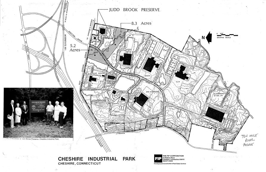
CLT's Ten Mile River and Judd Brook preserve are both associated with the Cheshire Industrial Park, and were both donated to CLT by the park's developer, FIP corporation.  

The Ten Mile River Preserve is located on the east side of Marion Avenue between Jarvis Street and Roger Avenue.  It is bounded to the south by the Town of Cheshire's Casertano Property, and a small piece borders the Ten Mile River to the east.  The Judd Brook Preserve contains two parcels, one to either side of Knotter Drive, both south of West Johnson Avenue.  (The Judd Brook Preserve is one of several CLT preserves actually made up of multiple parcels.) The Quinnipiac River Watershed Association has described Judd Brook as "a high quality permanently innundated floodplain swamp preserve."

Both properties are named for watercourses important to the Cheshire landscape.  The Ten Mile River watershed drains much of northwestern Cheshire.  Judd Brook is a tributary to the Ten Mile that starts in Southington.  Another major tributary is Cuff Brook.  The Ten Mile River's mainstem and surrounding areas contain a high level of biological diversity that has been extensively studied by QRWA and other organizations.  In particular, scientists have been interested in the area's reptiles, amphibians, freshwater mussels, and numerous vernal pools.

Judd Brook Preserve sign along Knotter Drive
Having protected lands within the watershed, such as CLT's two preserves, assists with maintaining wildlife habitats a and good water quality.  Additionally, the Judd Brook Preserve adds to natural areas viewed by workers at the industrial park's businesses, especially during lunchtime walks along Knotter Drive.

The Both the Ten Mile River Preserve and the Judd Brook Preserve are open to the public.  Judd Brook is the more easily accessible of the two.  Look for a small pull-off area next to to a CLT sign (pictured above) along Knotter Drive just south of West Johnson Avenue.  Neither property has trails.


Do you live or work next to or near the Ten Mile River Preserve or Judd Brook Preserve?  Tell us about what you've seen on this land!  Please join the Cheshire Land Trust at www.cheshirelandtrust.org to help us protect and maintain this and other great open space properties around Cheshire.

More about the CLT's wetlands preservation efforts are on the CLT website.


Tuesday, November 15, 2016

Day 15: Sylvan Lane Preserve

Forested open space and wetland.

Size: 5.5 acres
Nearest Road: Sylvan Lane
Public Access: Yes
Acquisition: May 1986
Donor: Richard Ziegler


The CLT's Sylvan Lane Preserve is tucked away at the end of Sylvan Lane, off Oak Avenue just south of Cornwall Avenue.  The property was donated to CLT in May 1986 by Richard Ziegler.  The property neighbors land associated with the Birchwood condominium complex to the south and east, with the Linear Park farther east.

Appropriate to its name, the Sylvan Lane Preserve is mostly wooded with hardwood species.  There are several large willow tress close to the Sylvan Lane cul-de-sac.  Willows are commonly found close to or in wetland areas, and much of this preserve is wet.  There is also a moderate cover of understory species, including spicebush, another common wetland indicator.

This is one of several CLT properties that contain utility easements.  The natural gas easement that passes through the Sylvan Lane preserve is easily seen in the airphoto above.  A benefit of such utility easements is that they create small breaks, in forested areas, that provide a bit of habitat diversity for wildlife species.  Because utility companies typically want or need vegetation along their lines to be low-growing (e.g. grasses and shrubs, not tall-growing trees with extensive roots), these areas provide important habitat diversity.  If not maintained, they would revert back to forestland, nudging out species that prefer or need grass and shrub habitats.

Willow tree silhouette - Sylvan Lane Preserve
The Sylvan Preserve is open to the public, but has no trails, and is rather wet during portions of the year.  There is a small CLT sign indicating the property at the end of Sylvan Lane.

Do you live next to or near the Sylvan Lane Preserve?  Tell us about what you've seen on this land!  Please join the Cheshire Land Trust at www.cheshirelandtrust.org to help us protect and maintain this and other great open space properties around Cheshire.  
More about the CLT's wetlands preservation efforts are on the CLT website at http://www.cheshirelandtrust.org/Wetland-Protection-properties.htm


Monday, November 14, 2016

Day 14: Fresh Meadows Wildlife Sanctuary

Wildlife sanctuary in meadow and forested setting.  Managed system of trails throughout for recreation and observation.
CLT's Fresh Meadows, and adjacent Elim Park property
with trails maintained by CLT.  Trails are shown in red.

Size: 32.8 acres
Nearest Road: Cook Hill Road
Public Access: Yes
Acquisition: June 1985
Donor: Cheshire Neighborhood Association


The Fresh Meadows Wildlife Sanctuary, or "Fresh Meadows", is one of CLT's marquee properties.  It is located in southeast Cheshire, on the north side of Cook Hill Road, just east of Elim Park and the Mill River.

Development can often come at a price. For Edward Tufte and other concerned citizens living around a proposed subdivision, the land's development was too high a price, and so began their efforts to organize and raise money to purchase the property and donate it to the Cheshire Land Trust. The Cheshire Neighborhood Association, a group of 8 neighbors, donated the 32.8 property to CLT in June 1985.

Fresh Meadows is an important natural area in the Mill River Watershed. Its meadows and emergent forests are really two properties. CLT owns 32.8 acres adjoining 10 acres owned by Elim Park that CLT manages. Fresh Meadows offers a well defined network of trails for easy walking in a natural setting making this open space an ideal place for all age groups. The diverse property includes mowed meadow, a forested ridge, Mill River frontage, seasonal wetlands, and a peat bog (former farm pond). 

"Fresh Meadows" was a name given much of south Cheshire by early settlers who farmed the low-lying, sparsely forested land along the Mill River. A tribute to an earlier respect for the land, Fresh Meadows is one of the Land Trust's most visible and accessible properties. CLT has worked vigorously to maintain trails and managed areas, permitting public access while protecting the plants and animals that live there. Among other animals, the property is wildly popular for birding.  It's also an excellent place to see a progression of wildflowers over the course of the growing season.

Fresh Meadows is open to the public, and has several blazed walking/hiking trails.  A small parking area and information kiosk are along Cook Hill Road, just at the base of the hill when travelling east from South Main Street.  When visiting, PLEASE stay on the marked trails and respect the privacy of our good neighbors! 

If you ever have 20 minutes to spare, the Fresh Meadows trails provide a great mini-escape into nature, not far from the busiest parts of town.  Much more about the property is on CLT's Fresh Meadows webpage.


Do you live next to or near the Fresh Meadows Wildlife Sanctuary?  Have you ever hiked the Fresh Meadows trails?  Tell us about what you've seen on this land!  Please join the Cheshire Land Trust at www.cheshirelandtrust.org to help us protect and maintain this and other great open space properties around Cheshire.


Sunday, November 13, 2016

Day 13: Briar Court Preserve and George & Frances Salvatore Memorial Preserve


Wetland preserves containing small stonewall and dam visible from Oak Avenue.

Briar Court Preserve

Size: 8.8 acres
Nearest Road: Ives Row
Public Access: Yes
Acquisition: November 1982
Donor: George W. Richard


George & Frances Salvatore Memorial Preserve

Size: 3.18 acres
Nearest Road: Oak Avenue
Public Access: No
Acquisition: May 1991

Donor: Frances Salvatore

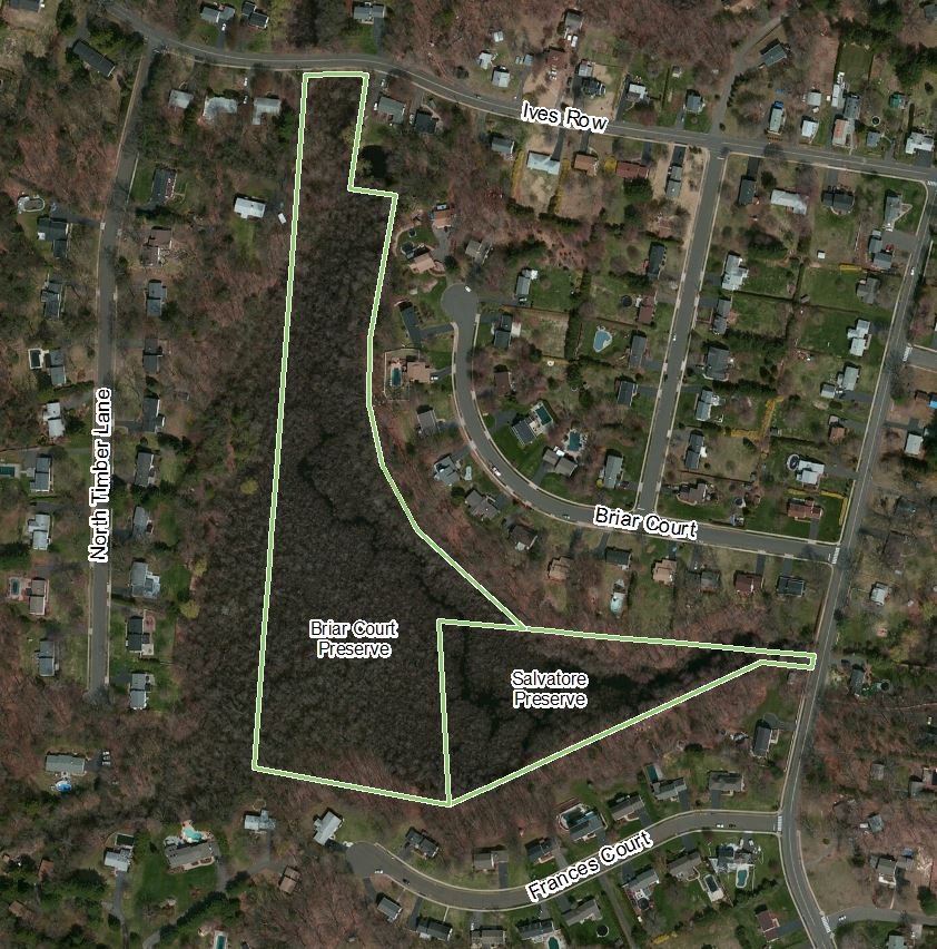
CLT's adjacent Briar Court Preserve and George & Frances Salvatore Memorial Preserve form a preserved open space corridor along a stretch of the upper Willow Brook watershed.  The properties are generally surrounded by the Briar Court, North Timber Lane, and Frances Court neighborhoods.

Briar Court Preserve was gifted to CLT in 1982; the George & Frances Salvatore Memorial Preserve nine years later, in 1991. 

Both preserves are in the vicinity of CLT's Strathmore Preserve and Willow Brook Preserve.  Combined, these four CLT properties wind through and around a number of neighborhoods that were the site of farms in (at least) the 19th and early 20th centuries. In particular, the area immediately around what is now Frances Court was previously part of the Salvatore family farm along Oak Avenue.  An aerial image from the 1934 Fairchild flight of Connecticut gives an idea of what the area looked like at that time.  While some farming in the 1930 is clearly evident, much of the area was actually wooded at the time.  The Fairchild flight is notable as the first statewide aerial photographic flight of the entire state of Connecticut, and provides a great tool for examining how our landscape has changed over the past 75 (so far) years.

Prior to the colonial farming, the the area was likely forested with a mix of hardwoods (e.g. oaks, maples, hickories) and possibly some softwoods (e.g. hemlock, pine), similar to the wooded areas seen in the 1934 picture.  The wetland boundaries of today may or may not be exactly the same as they were in years past.  While a cherished part of our cultural history, agricultural activities do at times push into wetland areas, altering and/or filling them completely.  The reduced amount of these areas and their functions on the landscape (such as flood control or wildlife habitat) was once reason they were designated for protection under several laws in the late 1960s and early 1970s.

Do you live next to or near the Briar Court or Salvatore Preserve? Do you live next to or near the Briar Court Preserve or Salvatore Memorial Preserve?  Tell us about what you’ve seen on the land!  Please join the Cheshire Land Trust at www.cheshirelandtrust.org to help us protect and maintain this and other great open space properties around Cheshire....